We firmly believe that the internet should be available and accessible to anyone and are committed to providing a website that is accessible to the broadest possible audience, regardless of ability.
To fulfill this, we aim to adhere as strictly as possible to the World Wide Web Consortium’s (W3C) Web Content Accessibility Guidelines 2.1 (WCAG 2.1) at the AA level. These guidelines explain how to make web content accessible to people with a wide array of disabilities. Complying with those guidelines helps us ensure that the website is accessible to blind people, people with motor impairments, visual impairment, cognitive disabilities, and more.
This website utilizes various technologies that are meant to make it as accessible as possible at all times. We utilize an accessibility interface that allows persons with specific disabilities to adjust the website’s UI (user interface) and design it to their personal needs.
Additionally, the website utilizes an AI-based application that runs in the background and optimizes its accessibility level constantly. This application remediates the website’s HTML, adapts its functionality and behavior for screen-readers used by blind users, and for keyboard functions used by individuals with motor impairments.
If you wish to contact the website’s owner please use the website's form
Screen-reader and keyboard navigationOur website implements the ARIA attributes (Accessible Rich Internet Applications) technique, alongside various behavioral changes, to ensure blind users visiting with screen-readers can read, comprehend, and enjoy the website’s functions. As soon as a user with a screen-reader enters your site, they immediately receive a prompt to enter the Screen-Reader Profile so they can browse and operate your site effectively. Here’s how our website covers some of the most important screen-reader requirements:
we run a process that learns the
website’s components from top to bottom, to ensure ongoing compliance even when
updating the website. In
this
process, we provide screen-readers with meaningful data using the ARIA set of
attributes. For example, we
provide accurate form labels; descriptions for actionable icons (social media
icons, search icons, cart
icons,
etc.); validation guidance for form inputs; element roles such as buttons,
menus, modal dialogues (popups),
and others.
Additionally, the background process scans all of the
website’s images. It provides
an accurate and meaningful image-object-recognition-based description as an ALT
(alternate text) tag for
images that are not described. It will also extract texts embedded within the
image using an OCR (optical
character recognition) technology. To turn on screen-reader adjustments at any
time, users need only to
press
the Alt+1 keyboard combination. Screen-reader users also get automatic
announcements to turn the
Screen-reader
mode on as soon as they enter the website.
These adjustments are
compatible with popular screen
readers
such as JAWS, NVDA, VoiceOver, and TalkBack.
this profile enables people with epilepsy to safely use the website by eliminating the risk of seizures resulting from flashing or blinking animations and risky color combinations.
this profile adjusts the website so that it is accessible to the majority of visual impairments such as Degrading Eyesight, Tunnel Vision, Cataract, Glaucoma, and others.
this profile provides various assistive features to help users with cognitive disabilities such as Autism, Dyslexia, CVA, and others, to focus on the essential elements more easily.
this profile significantly reduces distractions and noise to help people with ADHD, and Neurodevelopmental disorders browse, read, and focus on the essential elements more easily.
this profile adjusts the website to be compatible with screen-readers such as JAWS, NVDA, VoiceOver, and TalkBack. A screen-reader is installed on the blind user’s computer, and this site is compatible with it.
this profile enables motor-impaired persons to operate the website using the keyboard Tab, Shift+Tab, and the Enter keys. Users can also use shortcuts such as “M” (menus), “H” (headings), “F” (forms), “B” (buttons), and “G” (graphics) to jump to specific elements.
We aim to support as many browsers and assistive technologies as possible, so our users can choose the best fitting tools for them, with as few limitations as possible. Therefore, we have worked very hard to be able to support all major systems that comprise over 95% of the user market share, including Google Chrome, Mozilla Firefox, Apple Safari, Opera and Microsoft Edge, JAWS, and NVDA (screen readers), both for Windows and MAC users.
Notes, comments, and feedbackDespite our very best efforts to allow anybody to adjust the website to their needs, there may still be pages or sections that are not fully accessible, are in the process of becoming accessible, or are lacking an adequate technological solution to make them accessible. Still, we are continually improving our accessibility, adding, updating, improving its options and features, and developing and adopting new technologies. All this is meant to reach the optimal level of accessibility following technological advancements. If you wish to contact the website’s owner, please use the website's form

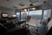
Očekuje se da studenti nakon položenog ispita mogu demonstrirati adekvatnu upotrebu RADAR/ARPA i ECDIS sistema. U vezi RADAR/ARPA sistema, od studenata se očekuje da budu sposobni izabrati adekvatan radarski domet; odabrati odgovarajuću radnu frekvenciju; fino podesiti sliku; promjeniti orjentaciju ekrana; plotovati mete i objasniti dobijene podatke uz osvrtu na PISM; mjeriti azimute i udaljenosti; postaviti GZ i PI; demonstrirati funckiju probnog manevra u cilju izbjegavanja sudara. Shodno radu sa ECDIS sistemom, od studenata se očekuju da mogu objasniti razliku između papirnih i elektronskih navigacionih karata odnosno između rasterskih i vektorskih elektronskih karata; izmjeriti azimut i udaljenost; pronaći detaljne informacije o objektima prikazanim na karti; odrediti poziciju pomoću referentnih terestričkih objekata; kreirati plan putovanja uz podešavanje svih sigurnosnih parametara; vršiti monitoring planiranog putovanja; izvršiti ručno korigovanje karata; ucrtavati mape; objasniti način ažuriranja elektronskih karata.
| Ime | Predavanja | Vježbe | Laboratorija |
|---|---|---|---|
| IGOR STANOVČIĆ | 1x0 | 3x7 28B+10S+7P | |
| IVAN MRAKOVIĆ | 3x7 28B+10S+7P |


 v1.jpg&w=220&h=150)